Sedimentological Reports
Sedimentary Geology of the Mesozoic Outcrops of Iraq - Correlations to the Subsurface and Implications for Hydrocarbon Exploration
Introduction
The primary aim of this project is to provide detailed petrographic descriptions of key outcrop sections from Northern and Western Iraq and to correlate these to well control points in adjacent areas.
The report provides a detailed account of the Mesozoic sedimentary geology of the Mesopotamian Basin in Iraq. Current sequence stratigraphic models for the basin are discussed, developed and refined, together with discussion of the implications for petroleum exploration in Iraq. The report also has relevance to exploration geologists working on the adjacent areas of Iran, Kuwait, Jordan and Syria.
- Petrographic logs and reports are provided for 6 outcrop locations - The total logged section is approx 14,000m, 43,000 feet.
- 1250 Photomicrographs.
- 16 Maps and Correlation Panels, 270 A4/A3 figures.
- Geochemical analysis and dating of selected intervals.
Sample and Data base
The study is based on measured outcrop sections from locations in Northern and Western Iraq which form part of the University of Reading Middle East Archive.
The Archive contains bed by bed field descriptions, plus thin sections and hand samples of the representative lithologies in each bed. The outcrop sections were originally measured, sampled and described, mostly in the 1950’s, by geologists of the Iraq Petroleum Company and were used, together with IPC well control, to establish the stratigraphy of Iraq as published in the Lexique Stratigraphic International (1959).
Samples in the Reading Archive include most of the formation type sections described in the LSI. This new study will provide detailed logs and descriptions for these sections based on modern concepts of stratigraphy, lithofacies and basin development.
This is the ninth study we have undertaken based on the Reading Archive. It compliments the earlier work by extending the regional picture from the Mesopotamian Basin margin, represented by the outcrops of the Western Desert of Iraq, through to the more distal portions of the basin, represented by the Zagros mountain outcrops.
Locations of analysed wells
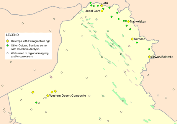
Report Contents Summary
Detailed logs are provided for each of the analysed outcrop sections, with a summary text illustrated with photomicrographs. The results are discussed in their regional context with illustrative correlations into key wells across the study area and conclusions on the implications for the petroleum exploration potential. The report is in PDF format with additional digital data provided in LAS, spreadsheet and GIS formats. The detailed logs show the original field descriptions, the new petrographic descriptions, results of dating and geochemical analysis, interpretations of depositional environments and stratigraphy.
Report Index
VOLUME 1 SYNTHESIS AND INTERPRETATION OF RESULTS (355 text pages plus 270 A4/A3 Figures)
Chapter 1. Introduction
Chapter 2. Stratigraphic Review
Chapter 3. Results and Interpretations of Stratigraphic and
Petrographic Analyses
3.1 Early Triassic
3.2 Middle Triassic
3.3 Late Triassic
3.4 Early Jurassic
3.5 Middle to Late Jurassic
3.6 Latest Jurassic to Early Cretaceous
3.7 Middle Cretaceous
3.8 Late Cretaceous
Chapter 4. Results and Interpretation of Geochemical
Analyses
Chapter 5. Conclusions
Chapter 6. References
Chapter 7. Appendices
A1. Table of formation tops for the analysed outcrop sections
A2. Results of geochemical analysis
Table: Results of TOC and Rock-Eval analysis
Table: Results of vitrinite reflectance measurements and visual kerogen descriptions
A3. Results of dating
VOLUME 2 RESULTS FROM OUTCROP TRAVERSES
Chapter 1. Jebel Gara Traverse
Chapter 2. Naokelekan Traverse
Chapter 3. Ora Traverse
Chapter 4. Sirwan-Balambo Composite Traverse
Chapter 5. Surdash Traverse
Chapter 6. Western Desert Composite Traverse
VOLUME 3 ENCLOSURES:
Maps
Location map
Petrographic Logs
2 Jebel Gara Outcrop Traverse, Triassic to Cretaceous Section
3 Naokelekan Outcrop Traverse, Jurassic to Cretaceous Section
4a Ora Outcrop Traverse (Lower Part), Lower to Middle Triassic Section
4b Ora Outcrop Traverse (Upper Part), Upper Triassic Section
5a Sirwan Outcrop Traverse (Lower Part), Lower to Upper Triassic (Sirwan/Balambo Composite)
5b Sirwan Outcrop Traverse (Upper Part), Upper Triassic to Jurassic (Sirwan/Balambo Composite)
6 Dalamar Outcrop Traverse, Upper Jurassic to Lower Cretaceous (Sirwan/Balambo Composite)
7 Jebel Balambo Outcrop Traverse, Lower to Upper Cretaceous (Sirwan/Balambo Composite)
8 Zimkan Valley Outcrop Traverse, Upper Cretaceous Section (Sirwan/Balambo Composite)
9a Nador Outcrop Traverse (Lower Part), Upper Cretaceous Flysch Section (Sirwan/Balambo
Composite)
9b Nador Outcrop Traverse (Upper Part), Upper Cretaceous Flysch Section (Sirwan/Balambo
Composite)
10 Surdash Outcrop Traverse, Lower Jurassic to Upper Cretaceous Section
11 Wadi Agar Muyat Outcrop Traverse, Western Desert, Triassic Section
12 Wadi Hauran Area Outcrop Traverses, Triassic to Jurassic Section (Western Desert Composite)
13 Lower to Middle Triassic, North Iraq to Iran
14 Lower to Middle Triassic, Jordan and Western Iraq to North Iraq and Iran
15 Middle to Upper Triassic, North Iraq to Iran
16 Middle to Upper Triassic, Jordan and Western Iraq to North Iraq and Iran
17 Upper Triassic to Lower Jurassic, North Iraq to Iran
18 Upper Triassic to Lower Jurassic, Western Iraq to North Iraq and Iran
19 Jurassic, North Iraq to Iran
20 Jurassic, Jordan and Western Iraq to North Iraq and Iran
21 Alternative correlation for the Sehkaniyan Formation at Sirwan, North Iraq.
22 Tithonian to Lower Cretaceous, North Iraq to Iran
23 Tithonian to Lower Cretaceous, Central to Northern Iraq
24 Middle Cretaceous, North Iraq to Iran
25 Middle Cretaceous, Central to Northern Iraq
26 Upper Cretaceous, North Iraq
27 Upper Cretaceous, Central to Northern Iraq
1 Jebel Gara Traverse.
2 Naokelekan Traverse.
3 Ora Traverse.
4 Sirwan-Balambo Composite Traverse: 4a Sirwan Traverse, 4b Dalamar, 4c Jebel Balambo, 4d Zimkan Valley, 4e Nador.
5 Surdash.
6 Western Desert Composite Traverse.
DIGITAL DATASET
GIS Mapdata
LAS Logdata
Formation tops
Geochemical Numeric Data
Photomicrograph database
AutoCAD LT drawings of the enclosures
Outcrop Traverses with petrographic logs generated in this study
Traverse Location |
Measured Thickness |
Stratigraphic coverage |
Type section coverage |
Jebel Gara |
1775m |
Basal Tertiary to Triassic |
Garagu, Chia Gara, Naokelekan (reference), Sarki, Baluti |
Naokelekan |
1850m |
Late Cretaceous to Trias |
Naokelekan |
Ora |
1700m |
Trias to uppermost Perm |
Kurra Chine, Geli Khana, Beduh, Mirga Mir |
Sirwan-Balambo composite |
5000m |
Basal Tertiary to Triassic |
Tanjero, Balambo |
Surdash |
1900m |
Late Cretaceous to Trias |
Qamchuqa, Sarmord, Sargelu, Sehkaniyan |
Western Desert composite |
850m |
Jurassic to Triassic |
Muhaiwir, Uba’id, Zor Hauran, Mulussa (reference) |